Trail Walking Le Lauzet-Ubaye - Gîte de la Roche.  - Photo
© OpenStreetMap contributors
Length
Length
3.9 km
Max alt
Max alt
1044 m
Uphill gradient
Uphill gradient
243 m
Km-Effort
Km-Effort  
7.1 km
Min alt
Min alt
789 m
Downhill gradient
Downhill gradient
247 m
Boucle
Boucle
Yes
Creation date :
2019-05-06 22:42:58.356
Updated on :
2019-05-06 22:42:58.356

(0 Reviews)

Walking
Walking
1h18
Difficulty : Easy

Scan this QR Code to open this trail in the SityTrail application

FREE GPS app for hiking

Logo SityTrail SityTrail

IGN / Geographical institutes

Download SityTrail from the App Store Download SityTrail from Google Play

Logo SityTrail SityTrail Plus

The world is yours!

Download SityTrail from the App Store Download SityTrail from Google Play Download SityTrail on Huawei AppGallery

About

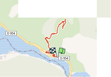
Trail Walking of 3.9 km to be discovered at Provence-Alpes-Côte d'Azur, Alpes-de-Haute-Provence, Le Lauzet-Ubaye. This trail is proposed by Dervalmarc.

Description

Gîte restauré par le conservatoire du Littoral.
Dominé par les falaises li se trouve à mi hauteur sur le versant méridional du grand Morgon.
Il offre une vue aérienne splendide de la branche Ubayenne du lac de Serre Poncon.

Elevation profile

Photos

Positioning

Country:
France
Region :
Provence-Alpes-Côte d'Azur
Department/Province :
Alpes-de-Haute-Provence
Municipality :
Le Lauzet-Ubaye
Location:
Unknown
Start:(UTM)
291811 ; 4925984 (32T) N.


Close
My subscriptions